How Deschutes County Search and Rescue built a drone program and uses Eagle Eyes to find missing persons in Oregon's toughest terrain
High on Oregon’s North Sister in July 2023, a jagged volcanic peak known for unstable rock and sudden weather, the search for a fallen climber had reached a difficult stage. The Civil Air Patrol was flying their WALDO camera system over the mountain, collecting wide-area imagery for analysis.
Watching the mission unfold on Flightradar24, Deschutes County SAR members Mark Tuttle and Jim Tuchschmidt learned from the Sheriff’s Emergency Management team that the resulting imagery would be available for review.
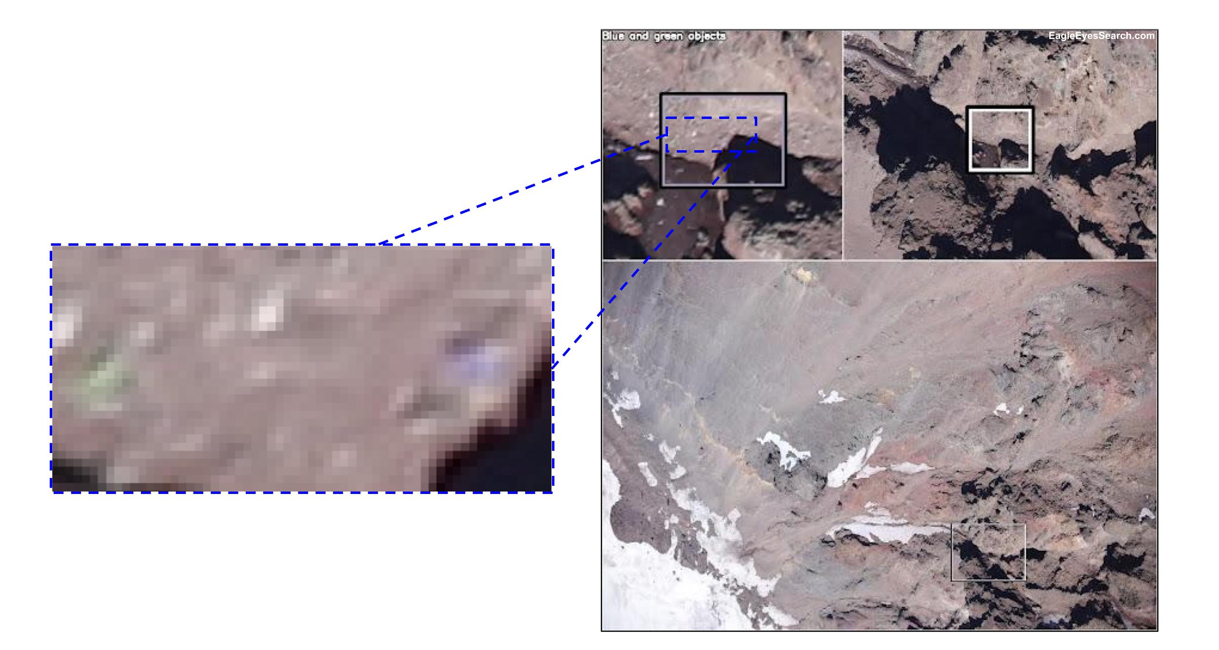
“Jim and I geo-referenced the photos onto a Google Earth relief of North Sister, then evaluated them in Eagle Eyes Scan”, Mark recalls. We were looking for pixel anomalies, not human remains.”
Those anomalies stood out. “Eagle Eyes detected multiple colored pixels, and we used those to identify approximate coordinates,” Mark says. The human remains were later confirmed near those points. “Eagle Eyes Scan was crucial in narrowing down the area and bringing closure for the family.”
That success didn’t come from a drone flight that day, but it made clear to the team at Deschutes SAR how much potential his drone operations team had.
Flying the unforgiving
Central Oregon is a proving ground for both people and machines. Snowy ridges rise above volcanic plateaus, dense forests give way to desert canyons, and weather can turn without warning. For the Deschutes County Search and Rescue Air Operations Team, every mission begins with uncertainty.
To understand how the team navigates that environment, we spoke with Dan Dawson, a coordinator for the Air Operations Team. “We can operate in all seasons,” says Dan, but “strong winds, heavy precipitation, and dense canopy can limit effectiveness and demand careful planning.”
Flying in these conditions is a mix of science, skill, and patience. Winter missions drain batteries fast, while summer heat tests both equipment and crews. Dense canopy and steep canyons make visibility a constant challenge. Pilots often need to fly at steeper angles and adjust their approach to scan gaps in the terrain.
“Particularly challenging flights are when operating below the launch point of the aircraft in deep canyons,” Dan explains. “That can affect aircraft visibility, radio link stability, and flight safety. Winds and turbulence, especially around ridgelines or within narrow canyons, add to the complexity.”

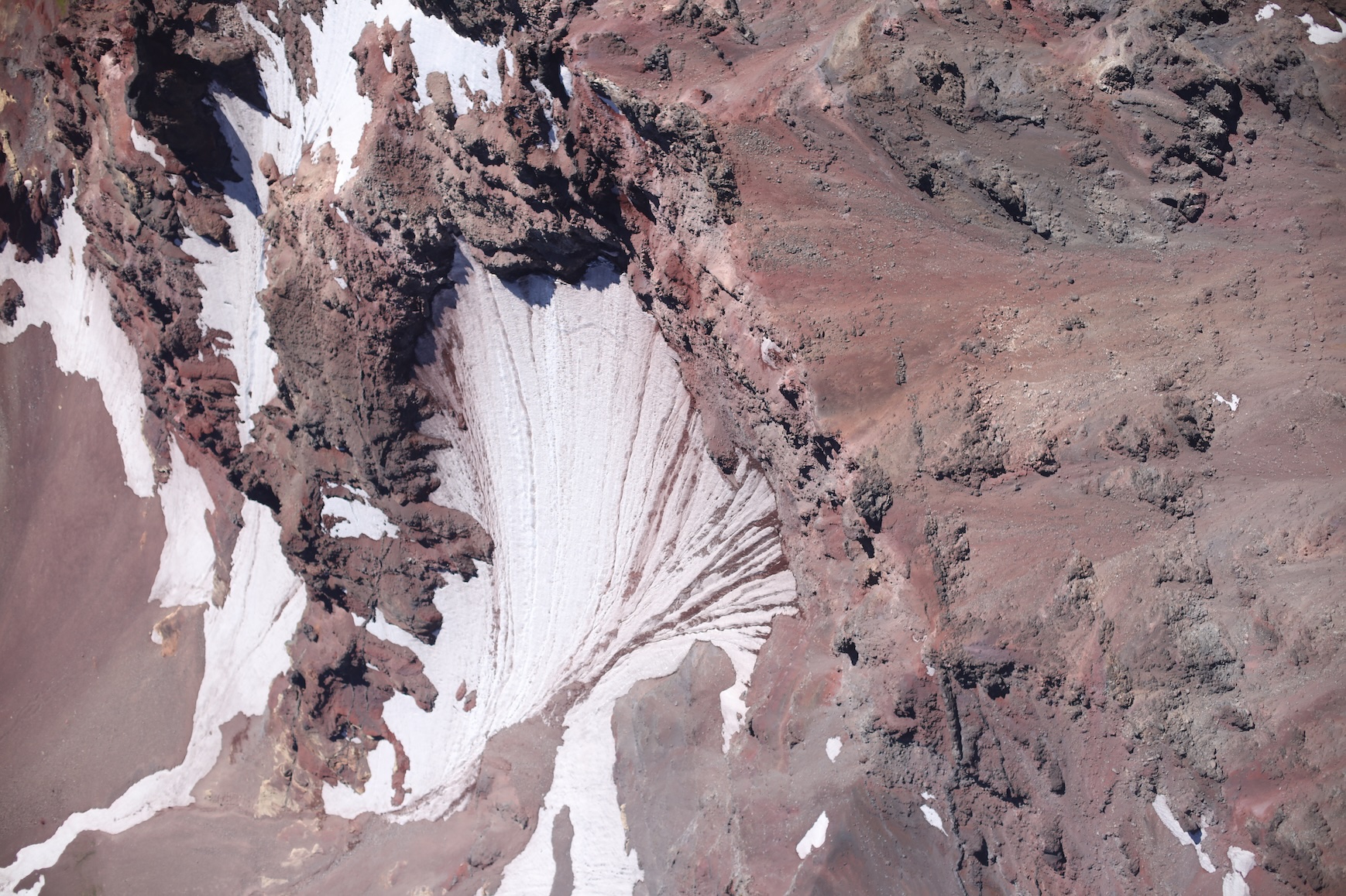
North Sister, a 10,090-ft (3,075-m) peak nearly 5 miles (8 km) wide. The jagged summit, dark volcanic rock, and lingering snowfields are all characteristic of the mountain's profile.
Ready for anything
Despite those conditions, Deschutes County’s Air Ops team stands ready for almost any mission. Drones can be launched at any stage of an operation, from early hasty searches to detailed mapping later in the response. The team’s missions range from searching for missing persons and documenting scenes to assessing avalanche hazards and supporting Mountain Rescue, Swiftwater, and Dive teams. By scouting terrain, identifying threats, and finding safe access routes before ground teams move in, the UAS crew helps make every mission faster, safer, and more informed.
When a search begins, the call to deploy drones usually comes from the Incident Commander or the Incident Management Team. “On certain mission types, qualified members may bring aircraft along just in case it’s determined they could assist,” Dan explains. Once activated, the Air Ops crew confirms pilots, aircraft, and objectives, then runs through pre-flight checklists to ensure safety and airspace coordination.
Flight strategies
No two missions are the same. “We use a variety of strategies depending on the mission, terrain, and pilot preference,” Dan explains. “Many of our operations lean toward semi-autonomous flights to ensure complete coverage and reduce pilot workload, but we also fly manual searches where the pilot positions the aircraft over likely areas using rough grids, trail corridors, or targeted sweeps.”
Flight altitude and coverage patterns are adjusted for each scenario. A common approach used by Deschutes SAR is to place an object similar in size to the target in comparable terrain to determine the highest altitude at which it can still be reliably detected. “For mapping flights, I prefer to be at least twice the height of the tallest object in the scene to ensure proper coverage.”
“Early in a mission, I often conduct a high-altitude ‘hasty’ flight to quickly cover a large area and document initial scene conditions - such as vehicles, tents, snow cover, and ground features - that can aid later planning.”
When canopy cover or other visibility challenges exist, the team flies crosshatch patterns or multiple angles to increase the chance of detection. If the subject is believed to be mobile, they revisit the same areas multiple times to look for changes. Thermal search patterns are similar, but Dan says he often begins with higher passes at night or in good thermal conditions to quickly spot heat signatures.
Training for the real thing
Mastering these techniques takes practice. Behind every flight is a long runway of training. New UAS volunteers are grouped into cohorts so they can learn together, building confidence through repetition.
“We move into flight practice as quickly as possible,” Dan says. “Understanding the theory is essential, but confidence comes from real-world flying conditions.”
Their in-house Flight Operations Manual serves as a foundation for training, but in the field, pilots rely on simplified one-page checklists for pre-flight, payload, and emergency procedures. “Checklists ensure standardization and safety,” Dan says. “They keep us aligned, especially under stress.”
He also sees value in standardized skill testing.
“We don’t currently use formal flight tests like the NIST Aerial Test Method courses,” he explains, “but having a consistent way to evaluate skills would make a big difference.”
Tools and Community Support
Training builds the foundation for flight, but maintaining a capable UAS program takes more than skill. It requires reliable equipment, proper infrastructure, and steady funding.
Deschutes SAR receives support from the Deschutes County Sheriff’s Office for mission-critical needs, while the Deschutes County Search and Rescue Foundation, a 501(c)(3) non-profit organization, raises additional funds through community events and sponsorships.
“Foundation funds help us purchase training and equipment beyond what the County budget can support,” Dan explains. “In the early days, we relied on grant funding to acquire our first aircraft and gear. While we no longer depend on grants for day-to-day operations, they were instrumental in getting us started.”
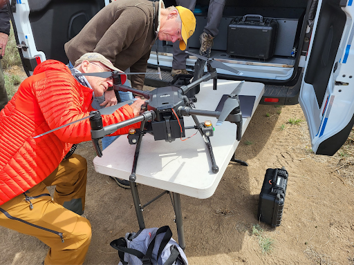
Among the team’s largest investments is their Air Operations and Incident Management Team van: a dual-purpose vehicle that supports both command and UAS operations. “The interior supports the IMT with workspace and communications, while the rear ‘garage’ area is outfitted for UAS operations, including charging stations, storage, a large viewing monitor, and weather protection. This dual-use approach allowed us to split the funding between teams while creating a resource that benefits the entire SAR operation.”
Extracting visual clues from data
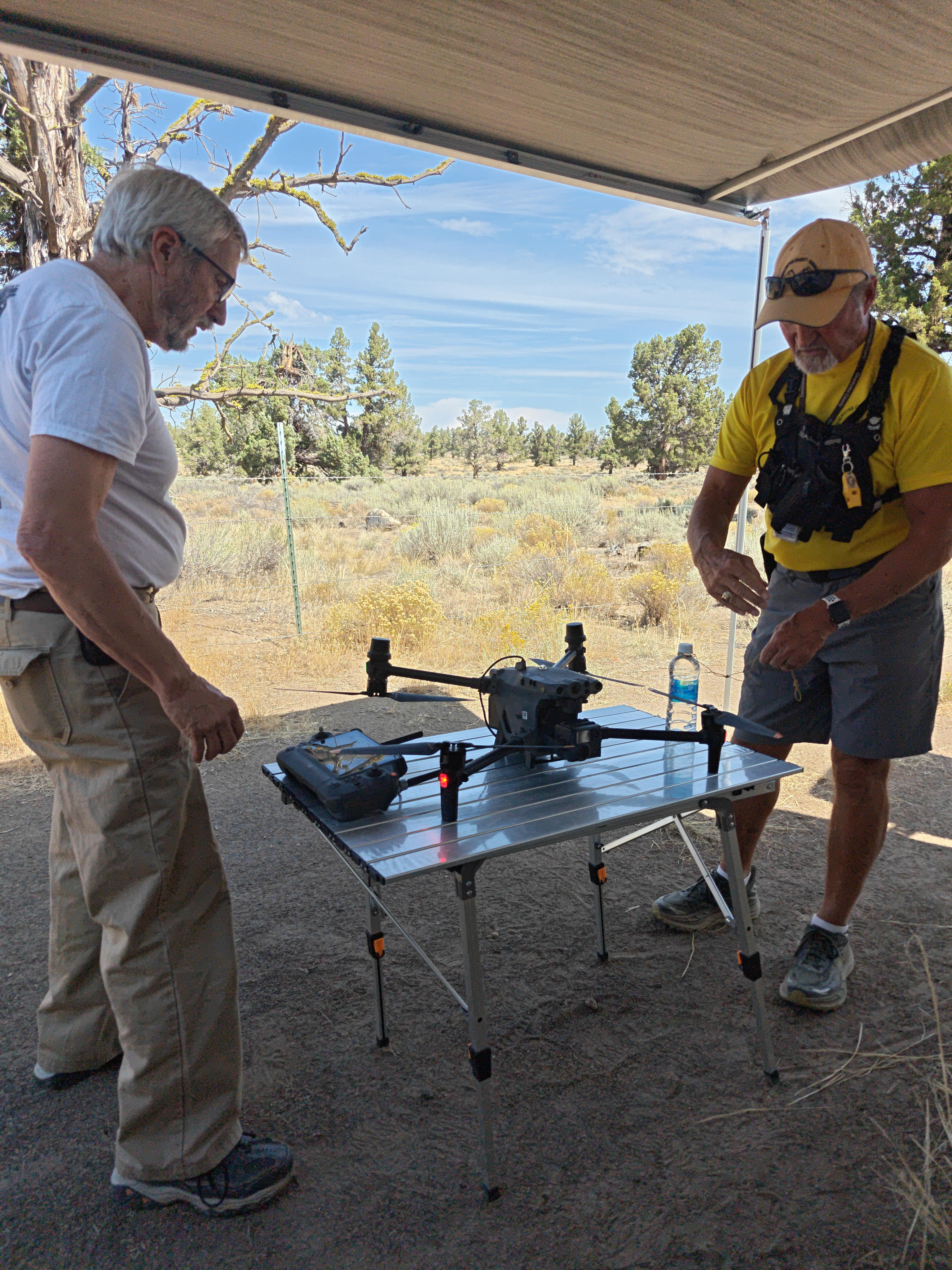
That same van now serves as the hub for much of the team’s live imagery review. “We have the ability to stream live video beyond the scene, but most of the time we review it right at the control station or inside the Air Operations van,” Dan says. “The van’s dark interior and large screen make it ideal for reviewing imagery with Eagle Eyes in real time.”
For Deschutes SAR, Eagle Eyes has evolved from a post-analysis support tool to a search partner in live operations. “It adds an extra layer of detection that helps catch details we might otherwise miss,” Dan remarks. “In our testing and training, Eagle Eyes has consistently proven its ability to detect clothing, brightly colored objects, or moving subjects,” Dan says. “These exercises give us confidence in its capabilities for live missions.”
Eagle Eyes is used wherever color or motion detection can make a difference - wilderness searches, avalanche paths, swiftwater operations, or evidence searches. “When possible, we run Eagle Eyes Pilot live on the controller so we can react to detections immediately,” Dan says. “If that’s not practical, we capture imagery first and process it later in Eagle Eyes Scan.”
Deschutes SAR has been involved with Eagle Eyes since the early days of the software. That early involvement also came through UAS volunteer Mark Tuttle, who worked on field testing and feature feedback. “The bottom line is that Eagle Eyes Scan and Eagle Eyes Pilot are very significant new pathways for our flight team to locate subjects in a timely rescue scenario,” he says.
From flight to insight
Much of the team’s work happens in real time, interpreting what the camera sees as it happens. But once the aircraft return and the day’s flights are complete, the focus shifts to detailed analysis. All imagery and video are uploaded to a shared Google Drive so other team members - both on-scene and remote - can review them.
“I create orthomosaic imagery for reference and planning in SARTopo/CalTopo, but I avoid conducting the actual search within the stitched mosaic because merging can obscure or blur clues. Instead, I review the original images individually, often with Eagle Eyes Scan, to maintain maximum detail and accuracy. Then the targets can be marked in DroneDeploy or SARTopo for additional flights or ground-team follow-ups.”
Looking ahead
Looking ahead, Dan expects longer flights, smarter autonomy, and tighter integration between mapping and AI. “Software like Eagle Eyes will be key to making sense of the huge volume of imagery we collect,” he says. “I anticipate a shift toward evaluating entire datasets to identify the most promising areas of interest. Integration with mapping tools like SARTopo could be transformative - imagine Eagle Eyes generating a map overlay that highlights areas for further investigation.”
He also sees collaboration between aircraft becoming a defining capability for future missions. “In multi-aircraft operations, I see live aircraft tracking and shared real-time data between UAS and command as becoming increasingly important. The ability to coordinate multiple drones efficiently, view their completed coverage in real time, and integrate detection results directly into the mission map could significantly improve search speed and effectiveness.”
Tips for other teams
Drawing on those experiences, Dan shared a few key lessons for SAR groups starting or growing their UAS programs:
-
Start small: Begin with smaller-area searches and build from there. Start with a reliable, compact aircraft with thermal capabilities so you have flexibility for both day and night operations.
-
Plan for upgrades: Technology moves quickly. Consider using an aircraft for only a year or two, then sell and upgrade to avoid being limited by outdated equipment.
-
Coordinate early with Incident Command: No matter how capable your team is, if IC/IMT does not understand or request your assistance, you will not be in a position to effectively contribute.
-
Cross-train internally: Cross-train with other teams such as Mountain Rescue, Swiftwater, and Tracking, so they understand how you can support them and will request you more often.
-
Cross-train with partner agencies: Start working with local law enforcement and fire agencies to make them aware of your team’s capabilities and how to collaborate on mutual aid incidents.
-
Standardize operations: Develop SOPs and checklists, and make their use standard in both training and live operations. This ensures safety and predictable workflows.
-
Plan funding and align platforms: Talk with nearby agencies about what they use. Shared platforms make training and mutual aid easier. Use grants, donations, or sponsorships to fill funding gaps.
-
Coordinate with crewed aircraft: In your SOPs, define exactly how you will coordinate with crewed aircraft during a search, including procedures for grounding UAS when helicopters or fixed-wing aircraft are inbound.
A reference to live up to
The experience on North Sister became a reference point for what disciplined workflows and sharp imagery analysis can accomplish.
That search started with fixed-wing aircraft, but the lessons from it helped shape Deschutes SAR’s modern UAS program. With stronger protocols, weather-ready equipment, and trained crews, the next successful outcome may come entirely from the drone team.
As Dan noted, “Our drone program already plays a crucial supporting role by guiding rescuers toward tracks, campsites, debris, or other clues that focus the search. Those contributions can be pivotal to the mission’s overall success.”
For Deschutes SAR, it’s never been about the aircraft; it’s about giving search teams every possible advantage. And with a drone program built for this, aerial search is fast becoming the backbone of their operations.
7 March 2026, by Joep Maas